Miami-Dade's charging story sounds rich until you leave the core. Brickell queues for its Superchargers; Doral clusters options around its retail; and then the county turns south and west and the network simply stops, forty-plus miles of it. Rapid Charge EV's dispatch log maps these deserts more honestly than any station app, because we are who people call from inside them. Here is the prose map.
- The deep south: south of the Kendall and Dadeland nodes, through Palmetto Bay and Cutler Bay, into Homestead and Florida City. The county's fastest-growing residential corridor and its emptiest charging stretch, ending at the Keys gateway where the stakes go up.
- The Krome edge: the western agricultural line from the Redland up past the trail crossings. Functionally zero infrastructure by design; the desert here is permanent.
- The Hialeah paradox: enormous population, thin charging, the densest underserved zone in Florida. Hialeah, Hialeah Gardens, Opa-locka, and stretches of North Miami share a ratio problem the buildout never addressed.
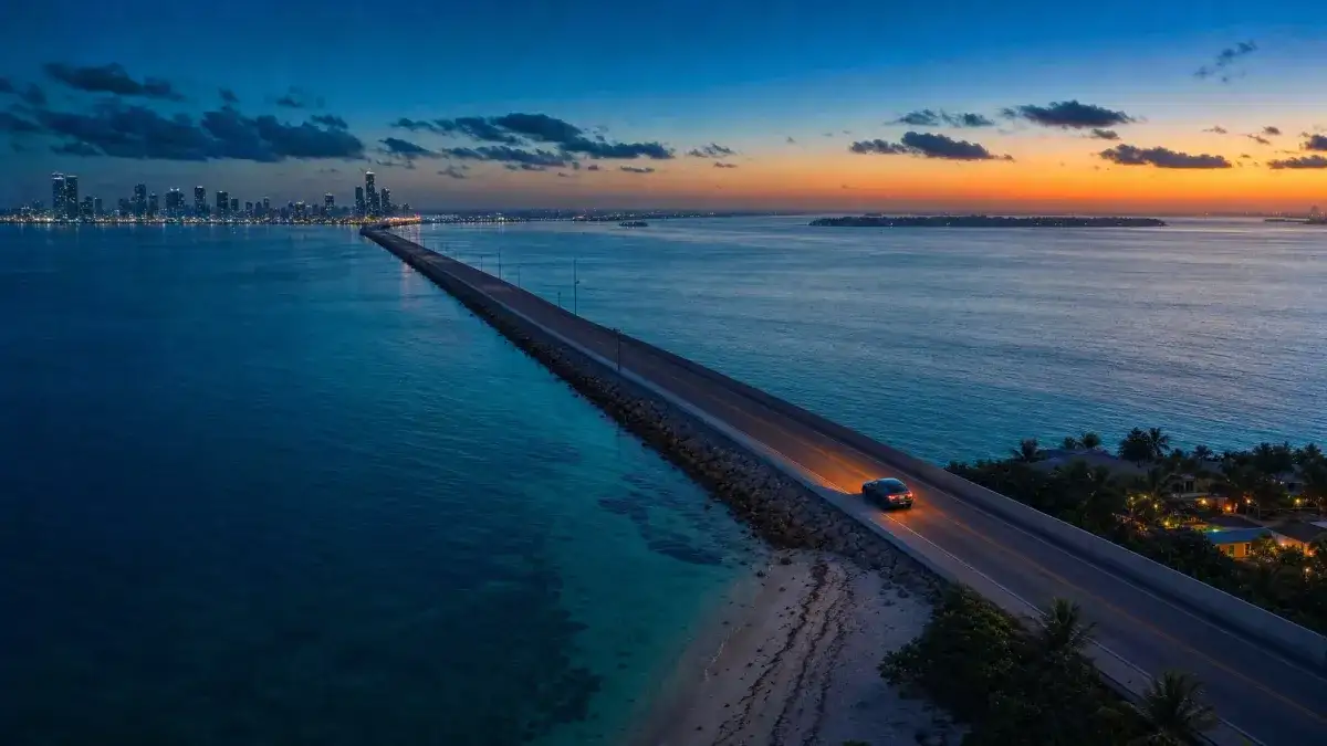
- The islands after dark: Key Biscayne, the Venetian chain, and the beach communities north through Surfside and Sunny Isles Beach, where daytime options close, lock, or queue, and every alternative sits across a causeway.
- The in-between west: Westchester, Fontainebleau, and the residential fabric between the Palmetto and the Turnpike, mile after mile of homes with retail strips that never hosted a charger.
Three forces drew it, and none of them are accidents. Station economics put chargers where retail dwell time lives, which in this county means the core, the malls, and the affluent nodes; Hialeah's strips and the south's commuter fabric lost that lottery. Land use closed the west: the Krome line borders farmland and protected Everglades, where infrastructure is not coming. And the island geography adds the causeway tax: even where stations exist, reaching alternatives means bridges, and bridges punish thin margins.
The result is a county where charging access tracks neither population nor need, and where the drivers with the least infrastructure often log the most daily miles.
South Dade households solve it at home or not at all: driveways and garages carry the installed-charging share, and the long commute north gets planned around a full overnight battery. Hialeah's renters and condo dwellers run the hardest version, opportunistic charging at work, errand-paired sessions at the few crowded nodes, and a growing reliance on delivered charging where buildings offer nothing. Island residents learn the causeway math cold: never cross home under 20% at night. And the Keys-bound learn the Florida City top-up ritual, the last reliable charge before the eighteen-mile stretch.
When the juggling fails, or before it fails, the delivered option is one call: (954) 278-4454, scheduled to your building, driveway, or island address on a standing cadence.
Delivered charging is the desert's native infrastructure: it scales to exactly the places the fixed buildout skipped. Our south-county routes run Palmetto Bay through Florida City weekly; Hialeah's building-bound EVs anchor scheduled stops; the islands get both standing visits and the after-midnight rescues. The honest caveat repeats: the deep south is the county's longest reach, and emergency ETAs there say so, which is the strongest argument for the scheduled pattern over the rescue pattern out there. The full county picture lives in our Miami-Dade mobile charging guide.
The deep south, Palmetto Bay through Florida City: home base is everything. Driveways and garages dominate the housing stock, so install or schedule, and treat the run north as a commute with a known cost. The Keys traveler's version: Florida City is the last call, top up there or budget the consequences, because the eighteen-mile stretch negotiates with no one.
Hialeah and the dense northwest: the hardest zone, and the one where creativity pays. Claim workplace charging anywhere it exists; pair errands with the few reliable nodes and learn their off-peak hours; and for building-bound vehicles, the scheduled delivery is less a luxury than the only structural answer, the buildings are not retrofitting any year soon, and a standing arrangement with Rapid Charge EV at (954) 278-4454 ends the weekly scavenger hunt outright.
The islands, Key Biscayne to Sunny Isles: live by the causeway floor, 20% after dark, no exceptions, and solve the building side the tower way, deck visits, valet handoffs, the patterns the core perfected. Island EV life works fine; it just refuses improvisation, and the bridge between you and every alternative is the reason why.
The western in-between, Westchester to the Turnpike line: suburban texture with urban thinness. The play matches Broward's west more than Miami's core, driveway-first, errand-paired nodes second, and a healthy floor for any evening that ends west of the Palmetto. Krome itself stays what it is: a boundary, not a route to improvise on.
Unevenly. The core will keep densifying, every new tower adds stalls, and the south's growth corridor should eventually pull infrastructure down US-1 behind the rooftops. But Hialeah's gap is economic rather than temporal, and nothing in station-siting logic has changed to favor it; the islands' after-hours problem is architectural; and Krome's emptiness is policy, the Everglades line is supposed to be empty. The county's deserts are not one problem with one timeline; they are four different problems, two of which are permanent, and planning that treats them as one problem keeps failing residents of all four.
The durable posture for Miami-Dade drivers: read your own zone honestly. Core dwellers wait out the buildout with delivered or building charging; southern commuters and island residents solve home base and respect the floors; the dense northwest treats the gap as structural and routes around it. The map rewards realism here more than optimism.
A closing note from the dispatch log: the county's desert calls cluster at the exact seams this post names, the US-1 run after dark, the Hialeah building lot, the island return, with a regularity that long ago stopped surprising anyone here. The drivers who never appear in that log are not the ones with better luck; they are the ones who treated their zone's gap as a fact to engineer around rather than a forecast to hope about. South of Kendall especially, that distinction is the whole game, and the engineering, a solved home base plus a saved number, takes less effort than a single stranded evening costs.
- South of Kendall: solve home base first, and never start the Keys run under 80%. The commute scenarios in our range anxiety guide cover the southern math.
- Hialeah and the dense northwest: claim any workplace charging you can, and put the building's gap on a delivery schedule rather than your patience.
- Islands: 20% is the causeway floor after dark, no exceptions.
- Krome and the edge: treat it like the wilderness boundary it is; the infrastructure analysis in our urban mobility post explains why that line will not move soon.
If you live, work, or drive in Miami-Dade's charging deserts and want them solved rather than survived, call Rapid Charge EV at (954) 278-4454 or email support@myrapidchargeev.com. We dispatch across Broward, Miami-Dade, and Palm Beach 24/7.